 FACULTY OF EXACT AND NATURAL SCIENCES
 FACULTY OF HUMANITIES
 FACULTY OF SOCIAL AND POLITICAL SCIENCES
 FACULTY OF PSYCHOLOGY AND EDUCATIONAL SCIENCES
 FACULTY OF ECONOMICS AND BUSINESS
 FACULTY OF MEDICINE
 FACULTY OF LAW


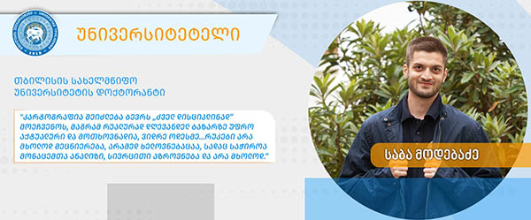 The names of young Georgian cartographers were first heard, among others, at the exhibition of children’s map competitions during the 32nd International Cartographic Conference “Mapping the Future: Innovation, Inclusion and Sustainability” held in Vancouver, Canada. This was made possible through the efforts of the six young cartographers themselves, the Georgian Cartographers Association, Tbilisi State University, TSU Junior (Children's University) and doctoral student Saba Modebadze, whom we introduce to you in our “University Student” column.
Saba Modebadze is a PhD candidate in geography at the Faculty of Exact and Natural Sciences at Ivane Javakhishvili Tbilisi State University. He is also the secretary general of the Alexander Aslanikashvili Georgian Cartographers Association and a member of the Cartography and Children Commission of the International Cartographic Association.
After completing his Bachelor of Science in Human Geography at TSU, Saba studied Geomorphology, Cartography and Landscape Planning in a master's program. Since 2023, he has been a PhD student in the field of geography.
“In my case, the choice was easy. I have been interested in geography since childhood, primarily due to my family. My father and brother, who are geographers, sparked my first interest. When my older brother enrolled in the geography department, he was an active student who collaborated with the Children’s University and was involved in projects. With his help, I followed the same path from my school age and decided to continue my studies at the same faculty. My geography teacher and the TSU Eco Club facilitated everything. The professors with whom I now have daily contact gave lectures there: Tengiz Gordeziani, Giorgi Dvalashvili and others,” says the young geographer.
Sports Atlas Cartography and Children's Cartography: A New Word in Geography
“Sports Atlas Cartography Methodology and Geoinformation System (on the Example of Georgia)" is the title of Saba's doctoral thesis. “Currently, one of the most relevant topics in Georgian cartography is creating a complex electronic atlas and a corresponding, constantly updated, evaluative geographic information system for Georgia and its municipalities. This topic is innovative and relevant to modern challenges. Sports geography is a new discipline founded by Vazha Neidze (in 1986), yet the field remains largely unexplored. “Sports Geography” is a new scientific discipline that studies the territorial distribution of people involved in sports and the organization of sports as a growing sector of the economy. In Georgia, this research is in its initial stages, because a comprehensive, constantly updated geographic information system is lacking. Nevertheless, based on the origins of athletes and teams participating in the country's championships, certain patterns are visible. For example, mountaineering is more popular in mountainous regions, wrestling is more popular in eastern Georgia, and sports games, especially football and basketball, are more popular in the west. “Sports atlas cartography” involves creating special atlases that show spatial, historical and social trends in sports through maps and diagrams for scientific research and practical analysis.”
Also, children's cartography is a relatively new field of cartography designed for children's age, cognitive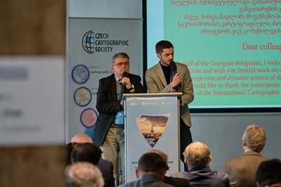 and educational needs. It creates simple, visible and educational maps, atlases and other cartographic products for children. I would like to explore the connections between sports, children's, school, landscape, historical and literary cartography. I think this will spark more interest in cartography.
Although cartography may seem like an “old discipline” to many, it is actually more relevant and in demand today than ever before. In the modern world, cartography is closely linked to geographic information systems (GIS), satellite data, drones, 3D maps and real-time navigation. That is why cartography is widely used in urban planning, environmental protection, transportation, logistics, tourism and economics. However, maps are not only a science, but also an art that requires data analysis, spatial thinking and much more.
“SKA” of Geographers and Cartographers
“GIS SKA” is the reimagined “GIS Group”, uniting students from Tbilisi State University and the Georgian Technical University. Lika Tsertsvadze, a geography student at TSU, is the author of the initiative and leads and coordinates the student group. In our case, SKA has two meanings: the first is its full definition, the Georgian Cartographers Association (in Georgian); and the second implies a “beehive”, a community of students interested in geography and cartography who work both within and outside the association. My duty at “GIS SKA” is to enrich the group with intellectual resources (students).”
 The implementation of various projects of GIS SKA is possible thanks to the infrastructure and support of the Faculty of Mining Geology and Sustainable Mountain Development at the Georgian Technical University and the GIS Center for Sustainable Development. The space is equipped with European-standard auditoriums, computers of the latest generation, a stereophotogrammetric drone, ArcGIS Pro licenses, etc.
The International Cartographic Association (ICA) has 28 thematic commissions, one of which is “Cartography and Children”. In 2023, an international symposium was held at Palacký University in Olomouc, Czech Republic, under the auspices of ICA: “Atlases, Their Design and Use.” I participated on behalf of the Georgian Cartographers Association. Children's cartography was an important topic among the reports presented at the symposium. After the symposium, I decided to organize a competition on this topic for students in Georgian public schools, under the auspices of the Georgian Cartographers Association. 27 municipalities, 54 schools and 159 students from 10 regions participated in “The World Seen Through My Eyes” competition. A commission of well-known scientists and practitioners evaluated the participants’ works. The competition aimed to popularize cartography and geography among school-age children and strengthen their spatial thinking. The TSU Children’s University and its employees - Marina Lomouri, Giorgi Grigolashvili, Elene Beberashvili and Demetre Modebadze - took an active part in organizing the competition.
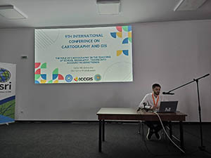
I presented the winning students’ works from competition at the international scientific conference “Cartography and Geographic Information Systems,” which was held in Nessebar, Bulgaria, under the auspices of the International Cartographic Association. My report on school cartography received high praise, and I was nominated to join the ICA Commission on Cartography and Children.
On International Children's Day in 2025, the Georgian Cartographers Association and TSU Children's University held final meeting and award ceremony for their children's map competition “Maps in Everyday Life” at TSU. As part of the competition, students from various grade levels presented their interpretation of the world through a map. Each piece clearly reflected the children's imagination, cartographic vision, and creative approach.
The 32nd International Cartographic Conference “Mapping the Future: Innovation, Inclusion, and Sustainability,” which took place in Vancouver, Canada, featured an exhibition of the Barbara Petchenik Children’s World Map Drawing Competition “Maps in Everyday Life.” The exhibition showcased 180 different visions from young future cartographers from around the world. For the first time, Georgia was represented at the exhibition by young cartographers: Lazare Okriashvili, Tinatin Gogishvili, Nino Kurashvili, Gvantsa Meparishvili, Elene Kikvadze, Nini Akhaladze, Anano Koberidze, Aleksi Mikadze, and Tazo Keshelava.
TSU – as an Opportunity
The Faculty of Exact and Natural Sciences at Tbilisi State University provides an opportunity for students to represent Georgia at the international level. As a master's student, I had the opportunity to participate in various international symposiums and conferences. In addition, for three years, I was involved in drafting memorandums of cooperation with Masaryk University in Brno (Czech Republic), Palacký University in Olomouc (Czech Republic), the University of Architecture, Civil Engineering and Geodesy (Bulgaria), and the Vienna University of Technology (Austria). I contributed to the Alexander Aslanikashvili Georgian Cartographers Association’s membership in the International Cartographic Association. Soon after, I became a member of the International Cartographic Association's Commission on Cartography and Children. Notably, the first and current presidents of the Georgian Cartographers Association, Jansug Kekelia and Tengiz Gordeziani, respectively, are members of various ICA commissions from Tbilisi State University. I am the third representative of TSU.
At the 21st International Conference on Geoinformation and Cartography (21stlCGC), where I was a representative of TSU, I presented a report titled “The Cartographic Heritage of Sulkhan-Saba Orbeliani.” Sulkhan-Saba Orbeliani is renowned as a writer, lexicographer, and diplomat, yet his contributions to the development of Georgian scientific geography and cartography remain relatively unknown. My report was based on the project “Study of Landscape Conditions and Atlas Geoinformation Cartography of Bolnisi and Tetritskaro Municipalities” (funded by Ivane Javakhishvili Tbilisi State University). Field and museum research was carried out in various territories of Bolnisi Municipality, including Tandzia, the native village of Sulkhan-Saba Orbeliani.
I plan to engage in children's university activities, such as TSU Envoy and Introduce Your Profession, together with a team of young students at the university. This will allow us to establish connections with more and more schools, teachers, and students with the help of the university.
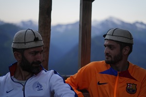 Since 2024, I have led field student scientific research expeditions aimed at studying and mapping regional landscapes in summer conditions. This research is conducted within the framework of a TSU-funded project and has a complex geographical nature. With Tengiz Gordeziani's guidance, I revived Professor Niko Beruchashvili's initiative to conduct summer field studies in landscape science and landscape cartography for students across the Caucasus. In August 2024, a student expedition was carried out in the Racha region as an attempt to revive this tradition. Another student expedition was held in the Bolnisi and Tetritskaro municipalities in August of this year. Notably, this is the first time since 1991 that a collection of materials from a student scientific conference has been published in Georgian and English in the field of geography and cartography. The materials are based on empirical data obtained and processed during the students' field research. Tengiz Gordeziani, an associate professor at TSU and president of the Alexander Aslanikashvili Association of Georgian Cartographers, mentored this project. The collection, "Racha Complex-Geographical Research and Cartography," includes ten scientific articles written by students and three scientific and methodological articles by supervisors. This work is a significant achievement in Racha complex geographical research and cartography, dedicated to its initiator and innovator, Prof. Niko Beruchashvili. The first expedition was presented at TSU during student conferences. A collection of materials from the student scientific conference is planned for publication in Georgian and German. A photo atlas is planned for publication in Georgian and German together with Alexander Wolodtschenko, a professor at Dresden Technical University. A student scientific conference is planned at TSU. In the future, I think summer and winter field expeditions for students should become inter-university and international projects.
In addition, I regularly organize student field trips, conduct practical classes, and promote student engagement. These activities strengthen the ability to work in a result-oriented and innovative manner. My goal is to create more cartographic products that interest children from an early age and inspire them to study the field. That is why I advise students to become interested in cartography, because it is a profession that combines science, technology, and art. It is constantly evolving and never loses its relevance. It provides an opportunity to contribute to the development of the country and global progress by participating in international projects.